Commuter & City Rail Transit Today
 In the period following the end of World War II automobile prices dropped, freeways were built,
and General Motors et al. purchased urban rail lines across the United States. Los Angles
fell in love with the automobile. After almost 90 years of rail history in Los Angeles'
the last remaining Red Car line went out of service in 1961 and the last street car line
followed suit two years later.
In the period following the end of World War II automobile prices dropped, freeways were built,
and General Motors et al. purchased urban rail lines across the United States. Los Angles
fell in love with the automobile. After almost 90 years of rail history in Los Angeles'
the last remaining Red Car line went out of service in 1961 and the last street car line
followed suit two years later.
The reality of freeway and street congestion along with poor air quality led to a renaissance of rail transit. In 1990 rail commuter trains and city transit trains began running again in Los Angeles.
Metrolink Commuter Trains
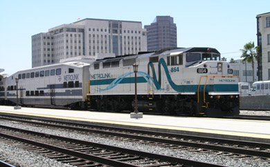
In 1991, following the passage of several ballot measures authorizing transportation improvements, the Southern California Regional Rail Authority (SCRRA) was established. Metrolink service began on Ventura, Santa Clarita and San Bernardino Lines in 1992.
As of December 2012, Metrolink operates 169 commuter trains daily on weekdays, 44 trains on Saturdays and 32 trains on Sundays between 55 stations on seven lines totaling 512 miles of track throughout Los Angeles, Orange, Riverside, San Bernardino Ventura, and San Diego Counties. Metrolink lines include:
- Ventura County Line (Oxnard to Los Angeles), 70.9 miles, stops at 12 stations.
- Antelope Valley Line (Lancaster to Los Angeles), 76.6 miles, stops at 11 stations.
- San Bernardino Line (San Bernardino to Los Angeles), 56.2 miles, stops at 13 stations.
- Riverside Line (Riverside to Los Angeles), 59.1 miles, stops at 7 stations.
- Orange County Line (Oceanside to Los Angeles), 87.2 miles, stops at 14 stations.
- Inland Empire-Orange County Line (San Bernardino to Oceanside), 100.1 miles, stops at 14 stations.
- 91 Line (Riverside to Los Angeles via Fullerton), 61.6 miles, stops at 9 stations.
An average of 43,990 riders use Metrolink trains each weekday. The authority owns 52 locomotives and 205 commuter rail cars.
For More information visit the Metrolink web site.
A 24 mile extension from Riverside through the Perris Valley to Perris opened in June 2016, lead by the Riverside County Transportation
Commission (RCTC). Trains operate Mondays-Fridays from four new stations: South Perris, Downtown Perris, Moreno Valley/March Field and Riverside Hunter Park/UCR, following the former ATFS right of way. Construction began in October 2013, for more information visit: www.perrisvalleyline.info and www.rctc.org.
Los Angeles Metro Train Service
 The
Los Angeles County Metropolitan Transportation Authority was formed in February 1993 from the
merger of the Southern California Rapid Transit District (RTD) and the Los Angeles County Transportation
Commission (LACTC). The MTA (Metro) currently offers local and commuter trains on four different
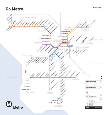
light rail lines and two subway lines within Los Angeles County. These lines include 98.5 miles of track serving 86 stations:
The
Los Angeles County Metropolitan Transportation Authority was formed in February 1993 from the
merger of the Southern California Rapid Transit District (RTD) and the Los Angeles County Transportation
Commission (LACTC). The MTA (Metro) currently offers local and commuter trains on four different
light rail lines and two subway lines within Los Angeles County. These lines include 98.5 miles of track serving 86 stations:
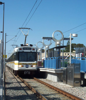
- The Blue Line (light rail), which opened in 1990, runs 22 miles, with 22 stations between Los Angeles and Long Beach, partially following the former Pacific Electric Long Beach Line.
- The Red Line (subway) runs between the Los Angeles Union Passenger Terminal, Wilshire Center, Hollywood, Universal City and North Hollywood. There are a total of 16 stations, 17.4 miles. The first segment of the line opened in 1993.
- The Purple Line (subway) shares the Red Line stations and track from Los Angeles Union Passenger Terminal to the Wilshire / Vermont station, then follows Wilshire Blvd to Wilshire/Normandie station and Wilshire/Western station at Western Avenue. Construction began on the first phase of an extension of the line to serve Miracle Mile and Beverly Hills, adding 3 new stations: Wilshire/La Brea, Wilshire/Fairfax, Wilshire/La Cienega, currently expected to be completed by 2023. The full project includes additional extension of the line and stations at Wilshire/Rodeo, Century City, Westwood/UCLA, and the Westwood/VA Hospital, a total of 9 miles, expected to be completed by 2035.
- The Green Line (light rail) runs between Norwalk, Los Angeles International Airport and Redondo, 14 stations, 20 miles. The line opened in 1995.
- The Gold Line (light rail) now runs 31 miles and serves 27 stations between East Los Angeles, Los Angeles Union Passenger Terminal and Azusa. The initial line running between Los Angeles Union Passenger Terminal and Pasadena, opened 13.7 miles and 13 stations in July 2003. An extension from LAUPT to East Los Angeles added 6 miles and 8 new stations in November 2009. An 11.5 mile extension from Pasadena to Arcadia, Monrovia, Duarte, Irwindale and Azusa, adding 6 new stations opened in March 2016. This extension follows the path of the first Atchison, Topeka and Santa Fe railroad line from San Bernardino to Los Angeles. An additional 12.3 mile extension to Glendora, San Dimas, La Verne, and Pomona, begins construction in August 2019 with planned completion to La Verne in November 2024 and North Pomona in 2025. Extenstion to Claremont and Montclair is pending funding. For more information visit the Gold Line website.
- The Exposition Line (light rail) currently runs 8.5 miles from
7th/Metro Center in Downtown to Venice and Washington Boulevards in Culver City, which opened in 2012. The line follows the Exposition
railroad right-of-way (former Pacific Electric) between Downtown Los Angeles and Culver City to the current terminus at Washington/National.
Nine stations have be constructed along the Exposition Line route.
 In addition to the
station at Washington/National, the stations are located on Flower at 23rd St. and
Jefferson, and on Exposition Blvd. at Vermont, Western, Crenshaw, La Brea, and La Cienega. Phase 2 which will ultimately extend the line 6.6 miles from Culver City to to 4th St. and Colorado Ave. in downtown Santa Monica, is projected to be opened in May 2016. Phase 2 will include 7 new stations: Palms, Westwood/Rancho Park, Expo/Sepulveda, Expo/Bundy, 26th St.Bergamot, 17th St./SMC and Downtown Santa Monica.
In addition to the
station at Washington/National, the stations are located on Flower at 23rd St. and
Jefferson, and on Exposition Blvd. at Vermont, Western, Crenshaw, La Brea, and La Cienega. Phase 2 which will ultimately extend the line 6.6 miles from Culver City to to 4th St. and Colorado Ave. in downtown Santa Monica, is projected to be opened in May 2016. Phase 2 will include 7 new stations: Palms, Westwood/Rancho Park, Expo/Sepulveda, Expo/Bundy, 26th St.Bergamot, 17th St./SMC and Downtown Santa Monica. - Construction on the Crenshaw/LAX Transit Corridor Line begain in 2014. The 8.5-mile light-rail line will run between the Expo Line on Exposition Blvd. at Crenshaw and the Metro Green Line at LAX. The line will include eight stations: Expo/Crenshaw, Martin Luther King Jr., Leimert Park, Hyde Park, Fairview Heights, Downtown Inglewood, Westchester/Veterans, and Aviation/Century.
This rail network currently includes include 98.5 miles of track serving 86 stations. During the heavy peak travel times, there are as many as 250 trains operating throughout the system, serving an average of over 333,000 passenger boardings per weekday. During peak periods the trains run every 5 to 10 minutes, running 10 to 20 minutes during off peak hours. larger map (pdf)
Bus service to and from each Metro Rail station is available from Metro Bus and community bus lines. Connections can also be made to Metrolink commuter rail service and Amtrak at Union Station.
View MTA planning map (pdf).
For more information visit the MTA web site.
San Diego Trolley - Metropolitan Transit System
The San Diego Trolley began operations on the South Line from downtown San Diego to the U.S. Border with Mexico in July 1981. The East Line opened to Euclid in March 1986 with an expansion to Spring Street in 1989. The South Line was renamed the Blue Line and the East Line was renamed the Orange Line. The Green line opened in July 2005 between Mission San Diego and Grossmont Center. The San Diego Trolley is a wholly owned subsidiary of the Metropolitan Transit System.
The system currently includes 53.5 miles of track on three routes, mostly double tracked, serving a total of 53 stations with 134 light rail vehicles. The system serves an average of 100,000 to 110,000 riders each weekday.
- The Blue Line operates between Old Town Transit Center, City Center, National City, Chula Vista, Imperial Beach and the U.S. Border with Mexico at San Ysidro. The line is 18.8 miles long.
- The Orange Line operates between the bay side in downtown San Diego, a connection with the Gold Line at the Grossman Transit Center,and the Santee Town Center. This line is 20.7 miles long.
- The Green line 5 provides service between the San Diego Old Town Transit Center, through Mission Valley, a connection with the Gold Line at the Grossman Transit Center, and the Santee Town Center. This line is now 19.3 miles long, which includes trackage shared with the Orange Line.
For more information visit the MTS San Diego Trolley web site.
San Diego Coaster Commuter Trains
The North County Transit District operates the Coaster commuter trains, linking communities and travelers from Oceanside to San Diego Mondays through Saturdays, with additional stops in Carlsbad (2), Encinitas, Solana Beach, Sorrento Valley and Old Town. The Coaster began service in 1995, and now caries nearly 6,000 commuters daily.
For more information visit the MTS Commute web site.
San Francisco Municipal Railway
The San Francisco Municipal Railway (Muni) is the seventh-largest public transit system in the United States, as measured by ridership. Muni's fleet includes subway-surface light-rail vehicles (Metro streetcars), electric trolley buses, the world-famous cable cars, and a unique collection of historic streetcars. Muni operates five electric rail lines and three historic cable railway lines. The first publicly owned streetcar system in a major city in the U.S., Muni has been providing public transportation since 1912.
Fore more information visit the San Francisco MUNI web site.
Sacramento Regional Transit
Sacramento Regional Transit opened its first 18.3 mile long light rail line in 1987, linking the northeastern (Interstate 80) and eastern (Highway 50) corridors with Downtown Sacramento. Expansions to Mather Field/Mills Station in 1998, to South Sacramento in 2003, Sunrise Boulevard in 2004, Folsom in 2005, and Sacramento Valley Station in 2006 have grown the system to 37.4 miles of light rail track today. The Blue Line extends from Watt/I-80 south to Meadowview, the Gold Line extends from Sacramento Valley Station east to Historic Folsom. This system includes 76 rail vehicles, 47 stations, 26 transfer centers, and 18 park and ride lots. Sacramento Regional Transit estimates they provide 51,000 average weekday passenger trips.
Fore more information visit the Sacramento Regional Transit web site.
Portland Streetcar, Portland, Oregon
The Portland Streetcars run on a 8.0-mile continuous loop (4.0-mile in each direction) from Legacy Good Samaritan Hospital at NW 23rd Avenue, to a terminus at SW Lowell and Bond.. Streetcar vehicles were manufactured by Skoda-Inekon in Plzen of the Czech Republic. They run in mixed traffic and, except at platform stops, accommodate existing curbside parking and loading. The Portland Streetcar is owned and operated by the City of Portland.
For more information visit the Portland Streetcar web site.
Freight Transportation Passenger Travel Commuter Travel
Sharing A Heritage Railroad History Train Technology Railroad Operation Railroad Time Museums & Heritage Railroads Railroads Today
Pacific Time |
Entire web site. copyright 2002-2019, DigitalNetExpress.com, Burbank, California. |